Clouds
Clouds are formations in the atmosphere that are made from minuscule water particles. During the water cycle water evaporates into the atmosphere, where it becomes a vapour (gas). As the warm vapour rises it cools and turns back into a liquid. These tiny particles of water join in the sky to form clouds. As clouds become bigger they become heavier with water and ice particles.
Clouds look white because the water in them reflects the light from the sun. Bigger and thicker clouds will often appear dark and almost black. These dark colours appear because the sunlight cannot pass through the clouds.
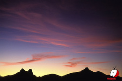
No two clouds in the sky are the same. Clouds can vary from low puffs of whiteness to high, large clouds that cover the entire sky. Clouds are able to tell us a lot about what is happening in the atmosphere. They can even help us predict the weather. See if you can make your own predictions.
All clouds have different names and all clouds form for different reasons. Clouds are often distinguished by their height in the atmosphere. They can be grouped into three atmosphere levels: low level clouds, middle level clouds and high level clouds, based on how close to the Earth they are.
The ten clouds types in order of closest to furthest are:
Clouds look white because the water in them reflects the light from the sun. Bigger and thicker clouds will often appear dark and almost black. These dark colours appear because the sunlight cannot pass through the clouds.
No two clouds in the sky are the same. Clouds can vary from low puffs of whiteness to high, large clouds that cover the entire sky. Clouds are able to tell us a lot about what is happening in the atmosphere. They can even help us predict the weather. See if you can make your own predictions.
All clouds have different names and all clouds form for different reasons. Clouds are often distinguished by their height in the atmosphere. They can be grouped into three atmosphere levels: low level clouds, middle level clouds and high level clouds, based on how close to the Earth they are.
The ten clouds types in order of closest to furthest are:
Nimbostratus
These clouds are low clouds that sit the closest to Earth's surface. They are dark in colour and they usually mean that there will be light to moderate rainfall. If temperatures are cold, nimbostratus clouds may contain ice and snow.
These clouds are low clouds that sit the closest to Earth's surface. They are dark in colour and they usually mean that there will be light to moderate rainfall. If temperatures are cold, nimbostratus clouds may contain ice and snow.

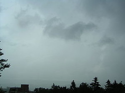
Stratus
These clouds are spread out across the sky. They are horizontal, layered clouds that looks like a blanket in the sky. They cover the whole sky as one solid cloud that is very grey. Stratus clouds form when warm air and cool air collide.
These clouds are spread out across the sky. They are horizontal, layered clouds that looks like a blanket in the sky. They cover the whole sky as one solid cloud that is very grey. Stratus clouds form when warm air and cool air collide.
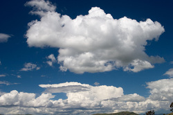
Cumulus
Cumulus clouds are characterised by their white and puffy appearance. They often look like large cotton wool balls and are a sign of a warm sunny day.
Cumulus clouds form as air rises and cools. The size of these clouds is dependent on the upward force of the air and the moisture. The stronger the force the larger the cloud will be.
Stratocumulus
Stratocumulus clouds come in varying shades of grey and appear across the sky as rolls of lumpy clouds. They form a layer across the sky which is broken in areas so that the clear sky can be seen in between the clouds.
Stratocumulus clouds come in varying shades of grey and appear across the sky as rolls of lumpy clouds. They form a layer across the sky which is broken in areas so that the clear sky can be seen in between the clouds.
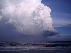
Cumulonimbus
Cumulonimbus clouds start as cumulus clouds. Cumulonimbus clouds reach high up in the atmosphere. These vertical cloud formations are very large and are like a cloud tower. Cumulonimbus clouds are the largest in the sky and can hold up to 91 000 tonnes of water.
Cumulonimbus clouds start as cumulus clouds. Cumulonimbus clouds reach high up in the atmosphere. These vertical cloud formations are very large and are like a cloud tower. Cumulonimbus clouds are the largest in the sky and can hold up to 91 000 tonnes of water.
Alostratus
Altostratus clouds sit in the middle of the sky and usually cover the whole sky. Their colour is often grey or blue-grey. These clouds are thin enough to see the sun and the moon shine through, although the light will be dull. Altostratus clouds usually form prior to a rain or snow storms. Rain often falls from these cloud types.
Altostratus clouds sit in the middle of the sky and usually cover the whole sky. Their colour is often grey or blue-grey. These clouds are thin enough to see the sun and the moon shine through, although the light will be dull. Altostratus clouds usually form prior to a rain or snow storms. Rain often falls from these cloud types.
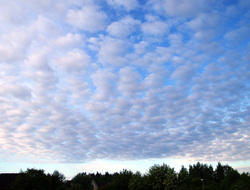
Altocumulus
Altocumulus clouds sit in the middle of the sky and look like parallel bands of clouds that extend across the sky. Blue sky can often be seen in between the bands. Altocumulus clouds that appear on humid summer days often signify a thunderstorm approaching.
Altocumulus clouds sit in the middle of the sky and look like parallel bands of clouds that extend across the sky. Blue sky can often be seen in between the bands. Altocumulus clouds that appear on humid summer days often signify a thunderstorm approaching.
Cirrostratus
Cirrostratus clouds form higher in the atmosphere and look like a giant sheet over Earth. They are most often transparent (the sun and moon can be seen through them) but at other times cirrostratus clouds can be very thick and heavy. Because cirrostratus clouds are so high in the sky they are often made of ice particles.
Cirrostratus clouds form higher in the atmosphere and look like a giant sheet over Earth. They are most often transparent (the sun and moon can be seen through them) but at other times cirrostratus clouds can be very thick and heavy. Because cirrostratus clouds are so high in the sky they are often made of ice particles.
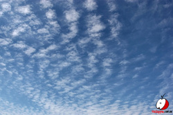
Cirrocumulus
Cirrocumulus clouds are the second-highest clouds in the atmosphere. These clouds are made up of individual cloudlets (small clouds). This array of clouds looks like a rippled pattern across the sky. These clouds often indicate unsettled weather is approaching. Just like other clouds that form high in the atmosphere, cirrocumulus clouds are also made up of ice particles. Cirrocumulus and altocumulus clouds are often difficult to tell apart.
Cirrocumulus clouds are the second-highest clouds in the atmosphere. These clouds are made up of individual cloudlets (small clouds). This array of clouds looks like a rippled pattern across the sky. These clouds often indicate unsettled weather is approaching. Just like other clouds that form high in the atmosphere, cirrocumulus clouds are also made up of ice particles. Cirrocumulus and altocumulus clouds are often difficult to tell apart.
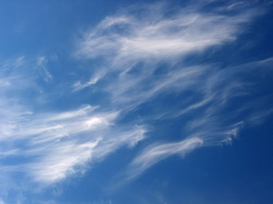
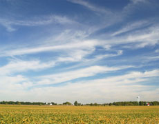
Cirrus
Cirrus clouds are the highest clouds in the atmosphere. Cirrus clouds are thin and often wispy looking. Because they are so high in the atmosphere, where it is colder, they are often composed of ice crystals. Cirrus clouds often indicate fair weather.
Cirrus clouds are the highest clouds in the atmosphere. Cirrus clouds are thin and often wispy looking. Because they are so high in the atmosphere, where it is colder, they are often composed of ice crystals. Cirrus clouds often indicate fair weather.
Thunder & Lightning
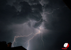
Thunder and lightning are caused by clouds. These clouds are referred to as storm clouds and are very large and dark. These clouds have a great deal of movement inside them (moving air, vapour and water particles). This movement creates millions of volts of electricity. Lightning is caused by the giant sparks of electricity within these clouds. Lightning can move from one cloud to another and down to the ground. Lightning can be very dangerous when it comes down to Earth.
Thunder is the sound of the lightning but because light travels faster than sound we do not hear the thunder until after we see the lightning. Thunder is often very loud but is harmless.
Thunder and lightning are common when the weather is warm and humid. Weather like this is often found in tropical climate zones and in many temperate climate zones during the summer season.
Rain, strong air currents, winds and hail often accompany thunderstorms. Australia experiences many storms, especially thunderstorms because it is a country that has both warm temperate and tropical climate zones.
